Ultra-rapid bathymetric mapping: a very useful technique in paleolimnological research
March 25, 2015 in Article by Davesne.G
Author: Frédéric Bouchard
The Geocryolab has recently acquired a simple, efficient and affordable lake bottom mapping system. The system consists of a portable echo-sounder (‘sonar’) equipped with a GPS, similar to those used by recreational fishermen for spotting fish shoals (Fig1, A ). The sonar can be installed quickly and simply in a small boat (zodiac) using plumbing pieces, Duct Tape and a bit of ingenuity (Fig1, B). Mapping surveys involve moving on lake surfaces along navigation lines while continuously recording water depths (Fig1, C). A separate software then allows to interpolate water depths between navigation lines in order to generate a high resolution bathymetric map (Fig1, D).
This technique was successfully tested in July 2014 on Bylot Island, Nunavut. In the context of our research in paleolimnology (history of ponds and lakes studying lacustrine sediment properties), this technique appeared very useful, if not crucial, for identifying the best location to sample lake sediment cores (generally, the deepest location within the lake). Moreover, as an important logistical advantage, the whole ‘kit’, including a small zodiac, can be deployed and used in the field by only one person, nicknamed the ‘Zodiac Sherpa’ (Fig1, E).
For further information: Bouchard et al ., submitted (GEOQuebec2015 abstract, to be confirmed).
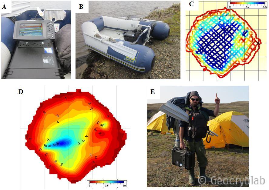
Figure 1 : A) Geocryolab’s portable sonar, which allows to continuously record lake bottom depths. Model 859XD with integrated GPS from Humminbird (photo: F. Bouchard); B) Sonar installation in a small zodiac. Sonar antenna is fixed outside the zodiac to stay on the water surface during navigation (photo: F. Bouchard); C) Navigation lines surveyed with the sonar. Depths are indicated by the color range; D) Bathymetric map generated from the navigation lines. We can see a deeper ‘trench’ (10-m depth), non visible from aerial photographs or other field surveys, which allows to quickly identify the best coring site; E) Motivated young researcher who carries, all by himself, the Geocryolab’s bathymetric mapping system to the next study site (photo: V. Preskienis)
Ce message est également disponible en : French

Ultra-rapid bathymetric mapping: a very useful technique in paleolimnological research
by
Geocryolab
is licensed under a
Creative Commons Attribution-NonCommercial 4.0 International License
.